Difference between revisions of "Laurel Highlands Hiking Trail"
Jump to navigation
Jump to search
(Add full 'hiking trail' infobox, copy in data from PJ's edit. Add photo caption. Add abbreviation w/ source.) |
|||
| Line 1: | Line 1: | ||
{{Infobox hiking trail | {{Infobox hiking trail | ||
| name = Laurel Highlands Hiking Trail | | name = Laurel Highlands Hiking Trail | ||
| − | | photo = Laurel_Highlands_Hiking_Trail_-_panoramio.jpg | + | | photo = Laurel_Highlands_Hiking_Trail_-_panoramio.jpg <!-- [[File:Ritter_Range_Pacific_Crest_Trail.jpg|200px]]<!-- Load Wikimedia Commons image here, ie CowlitzDivide.JPG --> |
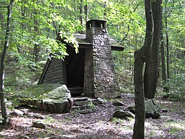
| − | | length = {{convert| | + | | caption = A shelter on the LHHT<!-- Mt Rainier from the Cowlitz Divide along the Wonderland Trail --> |
| − | + | | abbreviated_name = LHHT<ref>https://www.nps.gov/pohe/planyourvisit/laurel-highlands_end-to-end.htm</ref> | |
| + | | location = ? <!-- United States: California, Oregon, Washington --> | ||
| + | | length = {{convert|112.6|km|mi|0|abbr=on}} <!-- {{convert|4264|km|mi|0|abbr=on}}<ref name="Filley"> | ||
| + | {{cite book | ||
| + | | author = Filley, Bette | ||
| + | | year = 2002 | ||
| + | | title = Discovering the Wonders of the Wonderland Trail: Encircling Mount Rainier | ||
| + | | publisher = Dunamis House | ||
| + | | isbn = 1-880405-09-1 | ||
| + | | edition = 5th | ||
| + | }}</ref> --> | ||
| + | | trail_agency = ? | ||
| + | | trailheads = ?<!-- [[Longmire, Washington|Longmire Lodge]] <br/> [[Mowich Lake]] <br/> Ipsut Creek Camp Ground <br/> [[Sunrise (Mount Rainier)|Sunrise parking area]] <br/> White River Camp Ground <br/> Fryingpan Creek Trailhead <br/> Box Canyon <br/> Reflection Lakes <br/> Cougar Rock --> | ||
| + | | use = Hiking | ||
| + | | elev_gain_and_loss = ?<!-- {{convert|22000|ft|m|-2}} gain approximately<ref name="Filley"/> --> | ||
| + | | highest = ?<!-- Panhandle Gap {{convert|6750|ft|m|-1}}<ref name="SpringManningMRNP"> | ||
| + | {{cite book | ||
| + | | author = Spring, Ira | ||
| + | | author-link = Ira Spring | ||
| + | | author-link2 = Harvey Manning | ||
| + | | author2=Manning, Harvey | ||
| + | | year = 1999 | ||
| + | | title = 50 Hikes in Mount Rainier National Park | ||
| + | | publisher = The Mountaineers | ||
| + | | isbn = 0-89886-572-7 | ||
| + | }}</ref> --> | ||
| + | | lowest = ?<!-- Ipsut Creek Campground {{convert|2320|ft|m|-1}}<ref name="Filley"/> --> | ||
| + | | direction = ? <!--Nobo, Sobo...--> | ||
| + | | season = ? <!-- Summer to early Fall --> | ||
| + | | months = ?<!-- Mid-July through late September --> | ||
| + | <!-- | maintainer = ?<!-- National Park Service --> | ||
| + | | website = ?<!-- [http://www.nps.gov/mora/planyourvisit/the-wonderland-trail.htm nps.gov/mora/planyourvisit/the-wonderland-trail.htm] --> | ||
}} | }} | ||
| − | |||
{{Asbox | {{Asbox | ||
Revision as of 17:41, 11 October 2022
| Laurel Highlands Hiking Trail | |
|---|---|
 A shelter on the LHHT | |
| Length | 112.6 km (70 mi) |
| Location | ? |
| Trailheads | ? |
| Elevation | |
| Elevation gain/loss | ? |
| Highest point | ? |
| Lowest point | ? |
| Hiking details | |
| Season | ? |
| Months | ? |
| Website | ? |
| Direction | ? |
| Trail agency | ? |
| Abbreviated name | LHHT[1] |
| This article is a stub. You can help the community by expanding it. |
Contents
Overview
Length:
Standard direction(s) of travel:
Season:
Trail Association: