Difference between revisions of "Laurel Highlands Hiking Trail"
Jump to navigation
Jump to search
m (→Online Maps) |
|||
| Line 1: | Line 1: | ||
| + | {{Infobox hiking trail | ||
| + | | name = Laurel Highlands Hiking Trail | ||
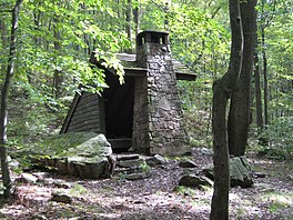
| + | | photo = Laurel_Highlands_Hiking_Trail_-_panoramio.jpg | ||
| + | | length = {{convert|70|mi|km|0|abbr=on}} | ||
| + | |||
| + | }} | ||
| + | |||
| + | |||
{{Asbox | {{Asbox | ||
| image = Ambox style.png | | image = Ambox style.png | ||
Revision as of 16:16, 11 October 2022
| Laurel Highlands Hiking Trail | |
|---|---|
 | |
| Length | 70 mi (113 km) |
| This article is a stub. You can help the community by expanding it. |
Contents
Overview
Length:
Standard direction(s) of travel:
Season:
Trail Association:
Permits and Regulations
Maps
Online Maps
Printed Maps
Information Resources
Websites
Apps
Guidebooks
Other
Sections
Water
Weather
Getting To and From the Trail
Resupply
Geographic Features
Administrative Territories
Online Communities
References